|
HOME |
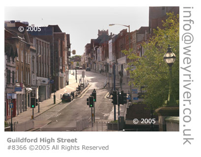
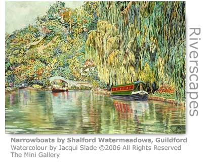
Godalming Navigation As the river approaches the County town of Guildford it skirts the edge of an historic hill that bleeds its golden sands into the waters. It is said that the 'golden ford', which for thousands of years provided safe passage to travellers across the river here, gave its name to Guildford the town. It is after Millmead Lock that the Wey Navigation, built a century before, continues the waterway's journey. |
Wey WEY LIFE
WEY LEISURE WEY BLOG "Not without incident, the walk had seen one team member savaged by a vicious dog and left gasping for life; another required first-aid surgery on their trousers after an unprovoked attack by a tree root; and we discovered the magical site of Surrey Hills brewery - makers of the very excellent Shere Drop." Blogger: BlogWalkers 4th February 2007
WEY FILM WEY RACES WEY BLOG WEY WALKER WEY LOCATION LOCATION WEY BOWLATHON WEY PILLBOXED "It would be very sad to see any pillboxes go," said Chris Shepheard, Tilford Rural Life Centre. "I think originally there were around 2,000 in Surrey, but incredibly many of them are being lost. What I'd like to see is someone to take on one of the pillboxes, restore it and open it up to the public." Source: Surrey Advertiser 24th October 2008 |
 |
||
|
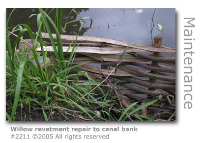
Traditional Skills About a quarter of a mile downstream from St Catherine's Lock this now natural course of the river makes a 180 degree turn to the west. To overcome the bargees problem of trying to have the carters’ horses pull around the corner without the haul ropes becoming entangled in the trees, a vertical rope roller (GR: SU995481) was installed. The National Trust has preserved this in situ. The swampy land opposite here, where the Navigation rejoins with the River Wey after half a mile of considerably contorted meanders to the east, was once an osier bed (GR: appSU995480). So named after the cultivation with osier willows that were grown for use in basket weaving, an ancient occupation common for centuries all along the Wey Valley. Osier willow (Salix purpurea) grows prolifically and its long slender pliable poles are perfect for weaving, and today are still used along the river for revetting the banks. This involves driving vertical stakes along parts of the bank that are collapsing into the river and between which willow poles are woven. This technique is called ‘spiling’. There are examples of these revetments along the stretch of the river near here. Osier beds, which are also called willow marshes, had the additional benefit of providing important natural habitats for wildlife. A large water extraction plant (GR: SU997479) is located near here on the Shalford side of the valley taking considerable amounts of water from the river to be filtered and pumped into the public water supply. This modern plant was built on the site of the centuries old Godwin-Austen family pile not far from the 19th century St Mary’s church that stands on the bank of the now largely obscured Tilling Bourne. Shalford would be a pretty backwater if it weren’t for the drone of traffic smoking its way along the busy Guildford to Horsham A281 that noisily dissects it. St Catherine's Hill, Chapel & The Ferry
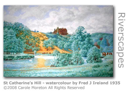
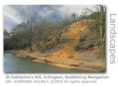
A striking sight as you continue to travel downstream, are the golden-orange sands sifting down into the river from St Catherine’s Hill just after another sharp bend which initially obscures the view very much adding to the impact. Just beyond the footbridge (GR: SU995483) here, built by the County Council in 1983 to replace the ferry that used to ply its trade, is the site of an ancient ford. Used for probably thousands of years the ford provided safe passage for the travelers wanting to follow the long-distance route now referred to as the North Downs Way, but was rendered impassable when the Godalming Navigation was built. The ferry’s landing stage can still be seen on the east bank of the river.
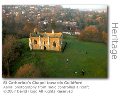
Historians suggest that this ‘golden ford’ gave its name to the town of Guildford just downstream. On the hill wedged between the main road from Godalming into Guildford and high above the river rests an ancient ruin, St Catherine’s Chapel (GR: SU994482) in Artington. Worth the steep climb up the sandstone hill, the whole hill can be felt to rumble as the busy London to Portsmouth railway spews trains through a tunnel dug deep into the hill beneath.
Building work commissioned by Richard de Wauncey, then rector of the Parish Church of St Nicolas in nearby Guildford, commenced in 1301. Sadly he died before the chapel could be consecrated in 1329, which for a time lead to a dispute over the lease for the land. The new rector eventually had the matter settled and ownership of the chapel has remained with the church ever since. There is a record of an older chapel on the site built by Henry II for ‘the use of his tenantry’ but which had fallen into disuse. A popular romantic notion is that the chapel was built for pilgrims traveling from Winchester to the martyr St Thomas à Becket’s tomb at Canterbury, at which they could pause for worship and rest. St Catherine’s Hill was perfectly located for such a purpose as the Pilgrim’s Way the travelers followed drops down to a point on the river Wey where they could call for the ferryman to row them across. More realistically the original purpose of the chapel was accorded to Richard de Wauncey’s desire that parishioners living some distance away from the main church could instead use this chapel-of-ease. There is actually no evidence that this route actually formed any part of a regular route for Canterbury Pilgrims. One hypothesis is that it is fairly modern notion popularized by a cartographic officer who inserted the name into the Ordnance Survey maps in the 1860s.
The river crossing point beneath St Catherine’s also had another significance. Artington Spring flows into the river at this point and had the ancient reputation of having astounding medicinal properties. Even until the late 19th century children were regularly despatched to collect the water, not only for drinking mixed with sugar or treacle, but also as local families found that the water was an effective cure for eye complaints. The spring had been held in sacred regard for centuries highlighted by the original Saxon name of Drakehull, translating to Dragon Hill, with contemporary legend stating that the healing spring was guarded by dragons. Modern scientific analysis of the waters have confirmed that like many springs in the area the Artington waters benefit from filtering through sandy and chalky soils which gives the water particular purity. Significantly the name of Artington itself hints at the strong religious history of the area with 'Artington' having evolved from the Old English 'Hertindon' meaning possibly 'hill of the people of the sacred hart'. The hill and the chapel became the centre of an annual five-day fair when in 1308 Richard de Wauncey successfully obtained a licence for this purpose from King Edward II. The fair was to become a great success and generated a significant income for the parish for many centuries. By the time the artist J M W Turner painted his watercolour of the fair in 1830, it had been reduced to a two day event. Nevertheless the fair was still extremely popular with local people, his painting showing much merriment and humorously highlighting the rivalry of two of the nearby hostelries through mocking graffiti scrawled over one of the marquees. Turner’s famous picture can be viewed on the plaque erected by the chapel.
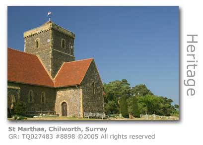
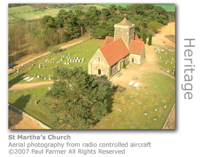
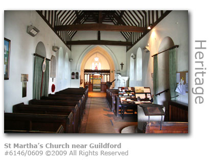
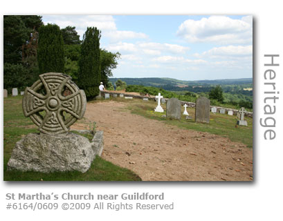
Over the ensuing centuries since the chapel fell into disuse various attempts have been made to repair the remaining outer walls. Significant rebuilding was commissioned in Georgian times by Robert Austen of nearby Shalford who valued the hill and its chapel as the focal point of a vista visible from his home. Today the chapel is obscured by trees that have been allowed to grow up around it. In the spring the hill is ablaze with daffodils. During excavations the remains of Bronze and Iron Age settlements have been discovered here. In current times the chapel remains under the protective wing of St Nicolas Church from where an annual service at the chapel is arranged to commemorate the chapel’s original consecration. St Nicolas Church (GR: SU994494) is located in Bury Street, Guildford under the care of the current rector Reverend Dr Andrew Norman. A carved marker post has been erected by the River Wey Group alongside the footbridge here to promote exploration of the riverside. MORE HERE The river all around the old ford is a very popular spot for cooling off in the water - easily accessible from Ferry Lane on foot. There is no public parking available on or near Ferry Lane. St Martha's Hill One local legend recalls that the church on St Martha’s Hill (GR: TQ 027483) above Chilworth, on the opposite side of the valley to St Catherine’s, was built by a giantess called Martha. The story goes that Martha constructed her church at the same time as her sister Catherine built hers, both with their own hands. The two sisters only had one working tool to share between them, an enormous hammer, which they tossed to and fro between the two hills as and when it was required. A popular notion is that 'Martha' may be a corruption of 'Martyr' to mark the fact that the hill had been where early Saxon Christians were martyred, although we are not aware of any factual evidence to support this claim. There is evidence that religious buildings have been sited on top of this hill for over a thousand years, promoted by both its commanding elevation and the fact that the hill is situated near the meeting point of two historically significant thoroughfares: the Pilgrims’ Way and the North Downs Way. St Martha’s Church, which is also referred to as St Martha on the Hill, is thought to date back to c1190 although the earliest documented reference to the church was made in 1224. There has been debate over mention in the Domesday Book (1086) of a church in the area although there is no conclusive evidence to say it referred specifically to the site on top of St Martha’s Hill. The church was ruined during the Dissolution of the Monasteries (1536 – 1540) by Henry VIII. Legend surrounding Martha as the Saint says that after the Ascension she left the Holy Land and settled in Provence in France. There a dragon lived on the banks of the Rhone terrifying the local people. Martha captured the dragon which was then killed. An alternative version says that Martha so impressed the beast with her courage that it became converted to a good dragon and subsequently assisted her in her works of mercy. The church was disguised during the Second World War to look like a clump of trees as it was felt that it provided too prominent a landmark that could be used by Luftwaffe bombers for navigation.
The fabric of the building, which is constructed of local Bargate stone and is of a cruciform plan (1), suffered considerable damage from frequent explosions at the gunpowder mills sited on the Tilling Bourne half a mile away at the base of the hill. One massive explosion in 1760 that killed two mill workers caused the church to partially collapse. The building was reduced to rubble eighteen years later by a further explosion which created total havoc in Albury, a village just upstream from the mills. The building was not fully restored until 1850. A well-known Guildford family under William Swayne, who was three-times the town’s mayor, owned a building company based in Burpham which was responsible for the rebuilding. Swayne also built Burpham Church in 1859. The Gunpowder Estate is an English Heritage Scheduled Monument. (1) A cruciform plan used in church design represents the shape of a cross and is common in Christian churches. This usually follows an east end where the altar rests and a west end containing the font, with north and south transepts forming the arms of the cross. MORE ABOUT THE CHILWORTH GUNPOWDER MILLS The positive organ (2) found near the door was restored by Kingsgate-Davidson & Co of London in 1949. A bell taken from the church now hangs at The Guildhall in Guildford High Street.
The recently refurbished headstones of Lieutenant- General Bernard Freyberg and his wife Barbara were attended in a ceremony at the church (September 2007) by the Prime Minister of New Zealand, Helen Clark. Freyberg (1889 - 1963) was New Zealand's most famous military commander who was awarded the Victoria Cross in WWI and commanded the New Zealand Expeditionary Force in WWII. Having completed service as Governor General of New Zealand in 1952 British born Freyburg returned to England, and after his death was buried in the graveyard of St Martha. The actress Yvonne Arnaud, in whose honour the theatre in Guildford was named, had her ashes scattered here and a memorial to her rests by the wall in the graveyard. The church, which today falls within the Diocese of Guildford for the Church of England, originally belonged to the Priory of Newark. The parish floodlights the church during the Christmas season. (2) A positive organ was designed to be easily moved and suits a small church like St Martha's. The Positive Organ Company, which specialised in their manufacture, built the organ found here.
The hill is of sandstone and at 573 feet (175 metres) high it is said that on a clear day eight counties can be viewed from one point. Archaeologists have found numerous Neolithic flint implements and flakes around the hill indicating that there was human habitation here for as long as 5,500 years. Earth circles were also created here and which are protected as Scheduled Ancient Monuments by English Heritage. At the foot of the hill nestles Chilworth Manor, an 11th century monastery. A nine and a half acre field beneath St Martha’s Hill to the south was purchased by the chairman of St Martha’s Parish Council to preserve it for the benefit of future generations to enjoy. The parish approached the Surrey Wildlife Trust for assistance in managing the land as a wildlife habitat. The church is only accessible by foot. There is a car park in Halfpenny Lane (GR: TQ:022453) with a picturesque walk up a steady climb of approximately a third of a mile (0.5km). Alternative access can be made from the car park in Guildford Lane (GR: TQ035485). The hill is the meeting point of the North Downs Way, the Pilgrim’s way and the Downs Link. (3) (3) The North Downs Way is a long distance footpath that covers 156 miles (251 km) through Surrey terminating at Dover in Kent. The Downs Link path runs 37 miles (59km) from St Martha’s hill to the South Downs Way in Steyning, West Sussex.
To the east of the church lies Colyers Hanger (GR: TQ035483), a Site of Special Scientific Interest (SSSI) and was listed as an important national site for conservation in Derek Ratcliffe’s original A Nature Conservation Review in 1977. This area of ancient woodland is of particular interest for its diversity. The coarse sands on the upper slopes of the ridge support oak, birch, hazel woodland and heathland. Beneath an exposed outcrop of Bargate stone are found ash and maple thriving on the light sandy soils leached from the outcrop. On the lower slopes are found alder. The latter two woodland types are rare in Britain. Wood was taken from here to supply charcoal for gunpowder. The plant small teasel Dipsacus pilosus, which is extremely rare in Surrey, can also be found here. A rare moss, Tortula marginata, thrives on the Bargate outcrop. The Surrey Wildlife Trust runs accompanied tours of Colyers Hanger. The western end of St Martha’s Hill through which the footpath approaches is registered common land. Parts of a 19th century plantation of larch and pine can be found in the Chantries (GR: TQ012482) to the west of Halfpenny Lane. The string of three hills including St Martha’s is referred to as St Martha’s Wooded Greensand Hills by Guildford Borough Council.
Sites of Prehistoric Spring Cult? A film maker with a special interest in British myths and cults contacted us to provide his own explanation as to how the names of St Martha's and St Catherine's may have come about.
Ric Kemp's regular blogs 'Through The Unknown Unremembered Gate' provide a fascinating insight into myths and cults and are based on his film research. 1. Dashwood, J B. ‘Thames to the Solent’, p20, 1868. European Recycling First at Albury The SITA UK-owned landfill site (GR: SU054484) off Shere Road at Albury has taken much of Guildford and Waverley's waste for many years and is near capacity, as the huge mound of excavated earth that towers above Weston Wood between the site and the village bears witness. The site, once a quarry from which clay and high grade building sand was excavated, is the location chosen by a commercial producer of natural fuels to produce the first liquid biomethane fuel (LBM) from buried waste in Europe, and is the second company in the world to do so.
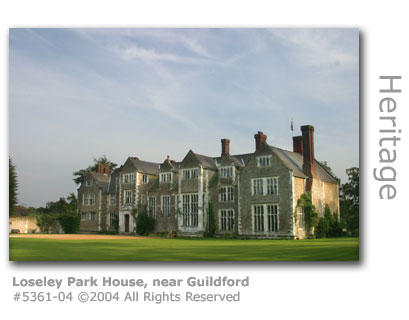
Gasrec, which had the planning go-ahead to install a carbon neutral liquefied bio methane plant and associated pipework in December 2006, pumped its first gas output into a tanker in June 2008. The firm had to adhere to strict planning constraints in construction of the plant including keeping plant architecture below 65ft (20m) and painting exposed structures green. Landfill waste is tipped into the quarry and spread out to be compressed into layers. Once each section is full it is capped by soil and the waste beneath begins to bio-degrade creating methane gas which is collected by pipes and fed into storage tanks for processing into liquid biomethane. The processing requires that the landfill gas is cleaned of impurities and then the methane, which makes up 50% of the output, is separated from other gases and liquified. Gasrec estimate that that the Albury site will yield 5,000 tonnes of biofuel annually, enough to fuel up to 500 large commercial vehicles. LBM fuel provides a renewable alternative to fossil fuels, and industry experts claim that it burns more cleanly and quietly than diesel with a 50 - 70% reduction in poisonous gases including nitrous oxide, a sulphur dioxide and carbon dioxide. The firm claims that use of the Albury LBM will reduce CO2 emissions by 15,000 tonnes per annum. Albury landfill is scheduled to close by 2012 although the gas extraction will continue for up to 15 years. The two original acres used for landfill was approved for sand working in 1957 and following exhaustion was authorised for waste disposal in 1980. Extraction of minerals at Albury was extended to an adjacent site to the landfill in 1989. The entire site covers 56 acres and by the end of 2008 is estimated to contain 500,000 tonnes of rubbish. 17 million tonnes of rubbish is dumped into landfill across England each year. The site has been the target of local and environmental concern for years. In 2001, following months of complaints from residents about pungent smells thought to have been due to large flocks of seagulls turning over layers of rotting garbage, two flare sticks were installed to burn off excess gas before plans were announced to activate two small converters for electricity generation on the site using the gas. Sita also had to reassure residents that no carcasses from a foot and mouth outbreak in that year were being buried there. A few years earlier in 1998 the site was at the centre of reported public concern over birth defects in farm animals rumoured to be caused by polluted groundwater although no evidence supporting the fears was forthcoming. Planning permission procedures state that once the site is closed it has to be returned 'to a condition suitable for forestry at ground levels so as to facilitate natural drainage and permit the carrying out of normal forestry operations.' Weston Wood once had a renowned arboretum of specimen trees including three sequoia trees which local parish councillors fear is lost forever. Gasrec Ltd successfully applied (March 2009) to install a generator at the site to run on gas collected from the landfill. Initially their application to build a 230sq m (2,476sq ft) steel-fenced compound was refused by the council planning inspector as it would affect the openness of green belt land but this decision was overturned by council executives. The company says that the 1mW of electricity produced will provide for all of its energy needs on site. Loseley Park Not far upstream from Guildford is the the Loseley Park Estate (GR: SU97473) with its 1,500 acres of parkland acquired by the direct ancestors of the More-Molyneux family in 1508. Loseley House itself was built between 1562 and 1568 by Sir William More (1519 – 1600) utilising stone brought from the ruins of Waverley Abbey, and remains to this day the home of three generations of the family. It is said that the construction of this fine house was conceived following a criticism levelled by Elizabeth I that the former house was too inadequate for her to stay in. Elizabeth returned to stay three times in the new house, and both James I and Queen Mary were also visitors.
The Great Hall contains panelling from Henry VIII’s Nonsuch Palace (Cuddington, near Epsom), which was demolished in 1682, carvings on the Minstrels Gallery by the Dutch-born woodcarver Grinling Gibbons (1648 – 1721), panels from Henry VIII’s banqueting tents and George IV's 1821 coronation chair in which he was anointed as spiritual head of the realm. The Drawing Room has a gilded ceiling decorated specifically for the visit by James I. There is also a 17th century Tithe Barn close to the house. The 'hlose' of Loseley is Old English meaning 'pig-shelter'. The More family history is considerably interwoven with the history of the Wey, as your journey downstream will reveal. The first member of the dynasty to live here was Sir Christopher More, a lawyer from Derbyshire who bought the original building from two families who were in dispute over the property. Fourteen generations of Mores and More-Molyneux have since owned and lived at Loseley. Mike More-Molyneux, the current owner, is the 15th. The estate fell into severe decline during WWII having lost most of the estate workers and with the house having suffered bomb damage. The current incumbent's father James was made an offer on the estate which he declined determined to return Loseley to its former glory. Over the ensuing 40 years he revived the estate by launching new enterprises to support it including Guildway Homes and Loseley Dairy Products. The dairy business, using the output from the estate's prize herd of Jersey cows, was launched in 1968 and quickly established a reputation for it's delicious ice cream, as many theatre-goers at the nearby Yvonne Arnaud will testify to. Loseley Dairy Products was sold to a Cumbria-based business in 1985 but the products still bear a picture of the house. Today three generations of the family manage the estate maintaining 100 acres of parkland, maintaining the house and over 50 other individual properties and buildings on the estate, and farming 1,500 acres of land. The Walled Garden in prominence today at Loseley is based on a design by the internationally respected local writer and landscaper Gertrude Jekyll (1843 – 1932) and has been significantly redeveloped since 1993. The Walled Garden is divided into five individually themed gardens including the award-winning rose garden that has been planted with over 1,000 traditional roses and one of the largest herb gardens to have been planted in England in recent years. A mulberry tree that is thought to have been planted by Elizabeth I during one of her visits resides in the gardens. The house and gardens are open to the public during the summer season attracting over 130,000 visitors every year.
Loseley House is a film location popular with directors. In January 2007 the TV production team for Midsomer Murders starring John Nettles and Jason Hughes spent three weeks at the house. Bentley Productions with director Sarah Hellings filmed an episode that will form part of the 10th series of the programme turning the house into the fictional Magna Manor. The episode entitled They Seek Him Here uses the theme of a film within a film with Inspector Barnaby investigating a murder on the film set at the manor. The episode which features scenes shot inside the house and in Loseley Park's grounds was broadcast on ITV1 in the late autumn (2007). Loseley was used by the BBC to film scenes for their mini-series of Jane Austen's Sense and Sensibility first broadcast in January 2008. The library featured as that of the character Colonel Brandon's, as did the front entrance. The Oak Room served as the set for the scene in which Marianne was cared for after her walk in the rain, and the exterior of the main house featured as the exterior of Sir John Middleton's home. The popular girl band Spice Girls filmed scenes for their film Spice World at Loseley Park. The 1998 musical comedy, which was slated by critics but achieved success at the box office in Europe and the US, has since been described as a 'cult classic'. Loseley featured in scenes for the 1978 British-American horror film The Legacy when it doubled as Mountolive Manor where guests are brutally murdered one by one. Loseley Park is featured in a new series of three books that examine some of Britain's most remarkable historic piles. Then and Now (April 2007) uses archived material and personal anecdotes from current owners and staff to provide an account of life behind the scenes. In 2008 Loseley Park celebrated its 500th anniversary of association with the More-Molyneux family by presenting an exhibition tracing the origins of the land and its owners to the present day. Loseley Park was shortlisted for the 2008 Tourism ExSEllence Awards. JMK Classic Catering, the caterers at Loseley Park won the Master of Culinary Arts Award for 2009. The award, in the restaurant management and service section, is an intensive test of skills covering all aspects of each discipline and is awarded by the Academy of Culinary Arts. The organisation claims that the Master of Culinary Arts is the highest achievement available to chefs, pastry chefs and restaurants in the UK and is based on the Meilleur Ovrier de France (1). (1) Created in 1924 the original competition Un des Meilleurs Ouvriers de France is given to the best craftsmen in France, and wasn't restricted to cooking and catering that included all types of crafts including cabinetmaking and masonry skills. The winner could boast as being ' one of the best craftsmen of France'. An environmental engineer who runs two businesses from the business park at Loseley set up (April 2009) the park’s own recycling scheme. Roberto Vogel, the owner of Vogel Industry Waste Services, established the Loseley Recycling Group which processes three and a half tonnes of waste annually from the eight business units including CHASE Hospice Care for Children. Compton Farm, which is part of the Loseley Estate, took the opportunity of an open day (May 2009) organised by the Jersey Cattle Society to showcase their own achievements in cattle management which includes reduction of lameness in the herd, a major factor in lower milk production and fertility. The farm has succeeded in reducing lameness in cattle by more than 50%, against a national average of 36.8%. Andy Marshall, the resident tenant farmer, was winner of the Royal Association of British Dairy Farmers (RABDF) Lily Hill Trophy (2008) for the best Jersey herd and a semi-finalist for the RABDF Gold Cup (2009). Loseley Park were voted (2010) one of Britain's top wedding venues by the viewers of The Best of British Wedding Venues television series broadcasted on Sky. SEE ALSO MOUNT BROWNE & SURREY POLICE HQ
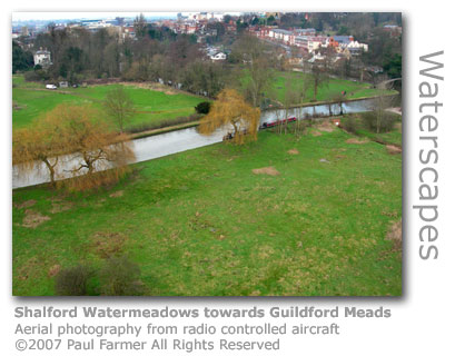
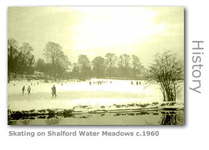
Within a stone’s throw of Guildford town centre lie the Shalford Watermeadows (GR: SU997486), a Site of Special Scientific Interest and the Guildford Meads. The meadows, which can be easily reached either directly from the River Wey as it runs alongside its east bank, or from the main Guildford to Shalford Road (A281), covers 57 hectares (140 acres). Consisting of open grassland and mixed broadleaf woodland, predominantly of alder by the river and ponds, the provision of footpaths and tracks allow easy access. The meadows are fenced to allow grazing by local organically reared cattle, and were also until the early 20th century utilised by the local population as a vast public skating rink when winters were considerably colder than they are now. One of the cows that can often be seen grazing on the land around the Shalford water meadows has won (July 2009) a national rare breeds competition. Crocus, a five-year-old Gloucester, is part of a herd used to manage the pasture and encourage biodiversity, and was crowned supreme champion at the Singleton Rare Breed Show at the Weald & Down Museum near Chichester. The Guildford graziers Luke Gates, Nicola O'Connell, and stockman Joe Hopkins who work at the Merrist Wood campus are no strangers at winning prizes, as in 2008 another cow from a herd won the same prize.
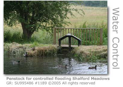
The Gloucester breed is classed as being at risk by the Rare Breeds Survival Trust. There are only 700 registered in the UK. There are penstocks alongside the Wey here which were built into the dyke that separates the Navigation from the lower lying meadows and allowed controlled flooding of this land. These served two purposes, the first as pioneered by Weston in his original agricultural initiatives to cover the meadow grass with water to counter the effects of frost, and the second as flood control measures to protect the town which had historically suffered from severe flooding. Shalford Watermeadows is managed by Guildford Borough Council in association with the British Trust for Conservation Volunteers (BTCV) group.
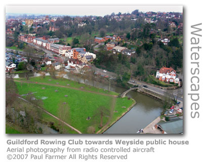
Guildford Rowing Club (GR: SU997488) on the east bank, just before the river takes a sharp turn northwards as it heads into the centre of Guildford, was founded in 1880 and has been built on the site of Davis’ Wharf. It was from here that chalk from extensive local quarries, including those at the base of Pewley Hill, were loaded onto barges to be used for the production of cement and fertilisers. Davis himself had two chalk pits at the Guildford Quarry leased from the Wey & Arun Canal Company from 1821.
On the opposite bank is a tumbling bay (GR: SU996489) that carries excess water from the Navigation down into a backwater, and that also serves today as a useful stretch of water for trainee canoeists and the occasional swimmer brave enough to plunge into the cold water. An additional sluice (GR: SU 996491) on the straight stretch in towards the lock provides relief in a town that for centuries had been plagued by severe flooding.
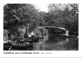
Just downstream from the rowing club the river takes a sharp left turn and passes under a footbridge (GR: SU 997489) - pictured above one year after its erection, here seen looking upstream. The sharp turn required haul rope rollers for the barges to be installed and these are affixed to the bridge, which was originally a grand wooden structure constructed from oak in 1909 and donated by a private benefactor to the town. The existing quite ugly concrete one replaced it in 1933.
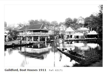
The Godalming Navigation now passes the quayside of the Weyside public house (GR: SU996490), formerly the Jolly Farmer, and heads on towards the last lock of Godalming Navigation. At the end of the 19th century the Victorians were in mid-swing with their enjoyment of the river and it was from the Jolly Farmer, then a plain grey building, that the Belgians, Charles and Alfred Leroy started their pleasure boat hire business.
They were the licencees at the pub and saw the opportunity of this sedate stretch of Navigation with good access to the water for launching punts for the town’s gentleman replete in their boaters and blazers to entertain their parasol shielded ladies. The Guildford Swimming and Life-saving Society shared the landing stage that had stood here. Competition arrived in 1912 when Allen’s Boathouse & Tearooms set up business in an elegant twin storied building just downstream, prompting Charles Leroy to move the boating business into larger premises alongside, after which The Jolly Farmer was rebuilt. Both boating buildings are now private residences.
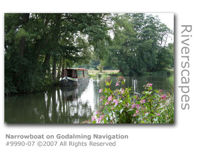
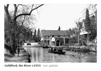
Pleasure boating was at its peak in the early 20th century and this pretty stretch of the town’s riverside was in full swing. The Leroy’s business was purchased by a Captain Charlie Hurst in 1943 who continued with it through the rest of the war until the 1960s. He ran a purpose-built passenger vessel called the Pilgrim which could peacefully power 30 trippers along the river with his electrically-powered motor, an initiative the National Trust have continued today with their pleasure boat operating from Dapdune Wharf further downstream. Allen’s Boathouse was sold after the war, but the site was eventually taken over by Guildford Corporation and incorporated into the Millmead car park in 1961. Guildford Boathouse (GR: SU 996491) on the same bank, today continues the tradition started by the Leroys in the 19th century. The Hurst business had been bought by Leslie and Marion Smailes upon his retirement and they relocated it to this site, building the boathouse with their accommodation above. They in turn retired and two families joined forces to run it in 1974, with the Chase family now continuing the tradition today. Ann and Bob Chase after retirement passed the running of the business to their sons Richard and Russell. Today (2009) Guildford boathouse operates with a fleet of 15 narrowboats that are hired out for holidays making the business the largest boat hire operator along the Wey. The business was shortlisted in the Toast of Surrey Business Awards 2009. The continuing success of the business is put down to continuity over thirty years of family ownership.
The boathouse commemorates the dedication of Harry Stevens to the Wey Navigation and of the contribution Alfred Leroy made to promote the enjoyment of the river. It was Stevens who donated the Navigation to the National Trust in 1964 and the 60 seater leisure touring boat that plies the river carries his name. They also operate ‘The Alfred Leroy’ providing river borne dining. Like its competitor by Catteshall Lock upstream, Guildford Boathouse contributes significantly to the running of the Navigations through financial contributions made by the licensing of their fleet of hire boats provided for public use. A painting, that until recently hung in the Yvonne Arnaud Theatre, depicts a ferry crossing the river at Millmead. The ferry at the old Millmead boathouse painted by Harry Goodwin in 1875 shows a very different picture of the river from today. When the artist put brush to canvas this section of the river directly opposite the theatre hadn't yet been diverted and the road had still to be constructed. The boathouse was under the buildings by Quarry Street. The oil on canvas measures 34 by 71 inches (86cm by 180cm) and is to be auctioned (January 2008) with an expected price of £6,000 to £8,000.
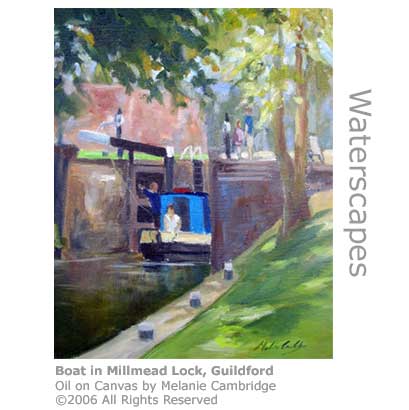
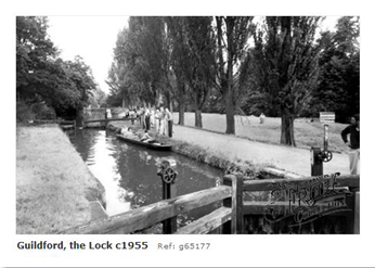
Millmead Lock (GR: SU996492) - rise of 6ft 3in (1.91m) - near the centre of Guildford, is the last of the Godalming Navigation locks and was opened when the canal from here to Godalming Terminus was completed in 1764. The Lock is 15.4 miles (24.8 km) from the Thames.
Millmead Lock footbridge was due to be replaced by the National Trust in November 2007 to provide improved access ramps and a wider bridge. The replacement, which was ordered after a routine inspection by Surrey County Council's rights of way department which had condemned the bridge as being unsafe, has had planning permission granted but a delay has resulted as the Trust continues to consider an unpublicised condition associated with the grant. A temporary bridge has been erected in the meantime. It is likely that the earliest opportunity to install the new permanent bridge will be in the winter of 2008. Move on to the first part of the Wey Navigation: © Wey River 2005 - 2012 |