|
HOME |
The River Wey South Branch A difficult valley to manage for farming provided the stimulus for developing the Wey Meadows method of water management. The river here also provided power for mills in an area of outstanding natural beauty. |
Wey WEY WILDLIFE WEY VALLEY FOOD WEY CULTURE WEY SPORTING WEY SHOCKING WEY MELLOW |
|
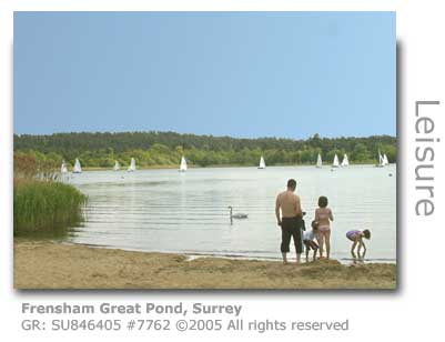
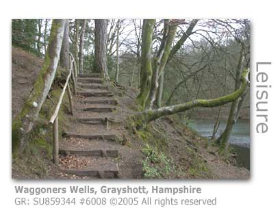
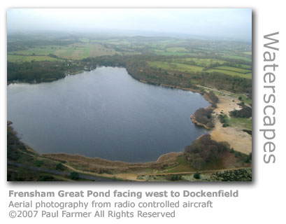
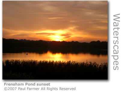
Wey Meadows This stretch of the river as far as Frensham was once renowned for the Wey Meadows which had been actively managed since the 1680s through until the early 20th century. Controlled irrigation, utilising water diverted onto the meadows from the river through a network of ‘carriers’ or man-made channels was funneled back into the Wey through drains and provided a system that greatly aided hay production. This system of improving agricultural yields was pioneered in Britain by Sir Richard Weston, the man who funded and masterminded the construction of the Wey Navigation. Rising on sandstone, unlike the North Branch which rises on chalk, the upper reaches of the South Branch of the Wey suffered from a difficult geology and profile being restricted by a relatively narrow valley and small irregular meadows. There is much evidence over many centuries of the construction of stone aqueducts to ease the flow of water servicing agriculture and industry. A series of channels and sluices survive in the water meadows of both Bramshott and Ludshott Manors. Near Radford Bridge a single arch stone bridge carries a brick lined water channel, and at Passfield two arches of a sluice survives. The remains of an aqueduct (GR: SU833334) is located not far from Bramshott at Bramshott Court, just downstream from the confluence of the tributary Cooper’s Stream. All around are large numbers of the water meadows system of field channels centering on GR: SU842323, all evidence to this concerted effort at effectively managing the Wey’s water flow in this part of the valley. The aquaduct between the sites of Bramshott paper mill and Standford paper mill has recently been restored (2005) by the River Wey Trust. Waggoners Wells Cooper’s Stream discharges from Waggoners Wells (GR: SU859342), a series of three ponds lying between Grayshott and Bramshott, and now a popular beauty spot. These ponds were formed by the creation of three dams in 1615 constructed by Henry Hooke to act as hammerponds for an iron mill planned for the site. There is no evidence of any mill or iron industry activity left today suggesting that the mill itself was never built. The surrounding Ludshott Common, managed by the National Trust, is one of the largest remaining areas of heathland in East Hampshire, and is a Site of Special Scientific Interest (SSSI) and also a Special Protection Area awarded because of the richness of its wildlife. There is a conspicuous concrete road (GR: SU858353) scarring the eastern side of the common. This was laid by Canadian troops who were stationed in the area during the Second World War and is a memorial to their Camp Superior which consisted of over 100 wooden huts, the foundations of some still remaining. Apple trees, rose bushes and privet hedges still remain in places, a leftover of the gardens the soldiers had cultivated. Local residents believe there to be a mass burial of Canadian military vehicles somewhere on the Common as it was deemed at the end of the war a cheaper method of decommissioning than shipping the surplus ones back to Canada. At Standford a paper mill once operated. Here there is a considerable water management system with a large millpond and weir where the old Standford Mill (GR: SU813350) drew its water to power the waterwheel for the hammers used in papermaking. Further downstream the part weatherboarded mill and house of the old Standford corn mill (GR: appSU813353) has been renovated to become the private residence Corn Mill Cottage. Frensham Ponds and Frensham Common The two Frensham Ponds, Great (GR: SU846403) and Little (GR: SU858414) sit in the middle of Frensham Common which provides a range of significant wildlife habitats including dry and wet heathland, reedbeds and alder carr, and pine and mixed woodlands. The common has various protective statuses including a Special Protection Area, a Site of Special Scientific Importance (SSSI), The Flashes Nature Reserve, an Area of Outstanding Beauty, the Kings Ridge Barrows as a Scheduled Monument, and an Area of Historic Landscape Value.
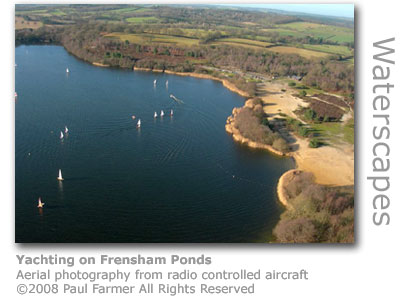
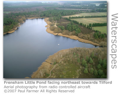
The Little Pond, owned and managed by the National Trust, is manmade and was formed when a dam was built in 1246. It was used to supply fish to the Court of the Bishop of Winchester when in residence at nearby Farnham Castle, and was drained on a five year year cycle to cleanse the soil and grow barley for brewing. The common and great Pond is leased to Waverley Borough Council by the National Trust which manages the area. Both ponds were drained in the Second World War to confuse enemy aircraft navigators and were subsequently used for tank training exercises until they were refilled in 1949. Pioneering flights of flying boats were carried out here after the First World War. A yacht club operates on Frensham Great Pond, and the common and both ponds are a popular leisure area.
A study released (February 2007) by the Environment Agency covered the 1,047 'most ecologically valuable' of Britain's 14,000 lakes and highlighted that 379 of them are severely degraded and in urgent need of rehabilitation. Frensham Great Pond was listed as one of those whose ecology is under threat, in its case by substances reaching the lake from earth being disturbed by road building and other developments in its catchment area. The lake is particularly interesting in that it has an ecology closer to lakes in the country's northern uplands. Nine of the country's 18 species of bats have been recorded at Little Pond. A hunt for bats by the Haslemere Natural History Society (September 2010) proved to be very successful.
A heathland fire on Frensham Common (July 2010) ravaged sensitive habitats and got perilously close to nearby homes. Surrey Fire and Rescue Service reckoned on their crews having saved property worth over £6m.
The brigade had mobilised more than 90 firefighters, and eventually managed to control the blaze by bulldozing a firebreak from Frensham Pond across to Little Pond. So fierce had been the blaze that residue crews supported by rangers and volunteers continued to monitor the site for another five days to ensure hotspots didn't re-ignite. Not surprisingly the wild and beautiful setting of Frensham Ponds has attracted film makers. Carry on Jack (1963) including Kenneth Williams, Bernard Cribbins and Juliet Mills had the Great Pond stand in for the Spanish coastline. Carry on Columbus (1992) with an all star cast including Bernard Cribbins, Peter Richardson, Maureen Lipman and June Whitfield similarly used the ponds to represent the American coastline. The Mummy (1999) with Brendan Fraser and Rachel Weisz also had scenes filmed here.
At nearby Frensham village, a late 14th century church (GR: SU842415) dedicated to St Mary the Virgin, with a Norman font has unwittingly became part of local legend which says that a white witch Mother Ludlum living in a cave near Waverley Abbey had had a copper cauldron stolen from her. Fearing for their lives the perpetrators had taken refuge in the church and the cauldron they had stolen still rests in the church to this day. Modern commentators however say that the large cauldron in the church had always been church property and would have been used for making and dispensing refreshments for the villagers at religious festivals.
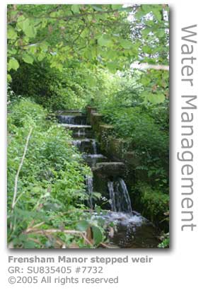
Frensham Mill (GR: SU837410) once part of the nearby manor (GR: SU837407) had two mill ponds, one of which was built on a small Wey tributary carrying runoff from Frensham Great Pond to ensure the corn mill had a constant supply of water even if the main river supply ran low. This large pond (GR: SU838401), which has a bridleway running between it and the expansive grounds of the manor house, feeds into the Wey about half a mile above where the mill was located. The first documentary map evidence of a mill sited here was in 1768, although a mill at ‘Feresham’ was highlighted in the Bishop of Winchester’s Rent Rolls of 1217. The mill had expanded to run three pairs of stones by 1876 when it was demolished and an even larger mill was built in its place becoming the largest mill in this part of the valley, although the timing appears to have coincided with the general downturn in millers’ fortunes as the mill closed in 1920. All that remains today of this once large 4 storey complex is the miller’s house and a three storey granary both of which can be seen from Mill Lane by the large mill tail pond. Frensham Mill Bridge (GR: 8484205) carrying the A287 from Farnham south to Churt is an arched 16th century bridge that was completely rebuilt in 1905 using some of the original material for facing to keep up appearances. There is a rare decorative fingerpost (GR: SU848423) made in cast iron opposite the post office at Millbridge north of here. The road sign dates from the late 19th century.
There were other mills operating in this part of the valley along tributaries to the Wey. At Barford (GR: SU854378) in the Whitmoor Vale, which feeds a stream rising from springs near Grayshott into Frensham Great Pond, there were three mills. Barford Middle was a corn mill in the 1700s that remained operational until the First World War, having been forced to close in 1914 when the axle shaft from the waterwheel snapped. The mill was demolished leaving the miller’s house to be converted into a private residence. The other two, Lower and Upper, were both paper mills, although reference is made to these having regular financial difficulties due to their remote location. Iron working using water power must once have been important here as a Hammer Lane runs up into the hills near the mill. A key initiative by county, district and parish councils together with local voluntary organisations was launched recently in the form of The River Wey Trust. The Trust seeks to undertake preservation and corrective work along the river with a small employed workforce and a band of volunteers. The range of the Trust’s interest is restricted to the Wey valley South Branch, between the Black Down source and the confluence at Tilford with the North Branch. The Trust welcomes new volunteers. If you want further information about the Trust and the research they've compiled along this part of the river hunt out a copy of The Southern River Wey pub 1990 (ISBN 0-9514187-0-X) published by the Trust. Copies are available directly from the River Wey Trust, 12 London Road, Liphook GU30 7AN. www.riverweytrust.org.uk Frensham Dairy Farm gifted to Countryside Restoration Trust Pierrepont Farm (GR: SU859423) in Frensham was gifted by Jo Baker in May 2006 to the Countryside Restoration Trust (CRT). The dairy farm includes 200 acres set in prime Surrey heathland and is sited next to the River Wey. The wet meadow owned by the farm is a Site of Special Scientific Interest (SSSI) established to protect the important flora habitat. Tenant farmers now run the farm which has a dairy supplied by a Pedigree Jersey herd. The Trust, in keeping with its remit, will run the farm as an example of a traditional dairy farm whilst demonstrating sympathetic wildlife management. Pierrepont is one of the last dairy farms in Surrey and is in good hands being managed by Michael Clear who moved to the farm having run a herd of Jersey cattle on the island of Jersey.
The Trust has launched a 'adopt a Jersey' campaign to raise funds. The 60 head herd welcomed six calves, Squirrel, Fanfare, Nutmeg, Moonlight, Tipple and Carla, born in January which are being offered up for 'adoption'. Adopting will allow you to follow your calf's progress and get to meet up too. The Countryside Restoration Trust is a small charity that currently manages nine farms around the country. Their intention is to demonstrate profitable farming whilst blending traditional thinking and sustainable modern methods to restore wildlife and maintain rural culture. Source: In an increasingly beleaguered dairy industry beset by problems imposed by price squeezes from the major food retailers, Pierrepont Farm has in its unique arrangement through ownership by a charitable trust a more promising future. Many dairy farmers are living on the poverty line with farm-gate milk prices around 18p per litre, the lowest in Europe. The problems are traced back to the dissolution of the Milk Marketing Board in 1994 after EU regulations on competition were implemented which put milk prices into freefall.
However the big retailers are now beginning to realise that more and more dairy farmers, who typically are having to work 70 hour weeks with only four day holidays a year, are being forced to abandon the industry and that something needs to be done to redress the situation before the milk supply chain collapses completely.
One of the key difficulties imposed by low pricing is the inability for farmers to invest into their businesses for the future, a problem lessened for Pierrpont Farm by the support provided by the charitable trust. In common with the four other farmers supported by the trust Clear can plan for the future.
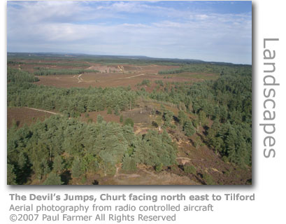
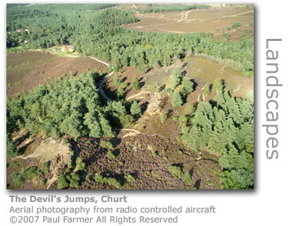
Source: The village of Churt with a population of 1,098 (2001) lies on the Surrey Hampshire border and has been a site of human settlement since Neolithic times. Within a five mile radius archaeologists have recorded evidence including Neolithic flint tools, Bronze Age burial mounds and remains of Roman buildings. A mammoth tusk and bones were found nearby. The first record of Churt was in 688 AD when Caedwalla's charter gave land around 'Certe' to the church. Several iron mills were located nearby taking power from the stream running through Whitmoor Vale. The village did not have its own church until 1838, the current building of St John the Evangalist having been constructed to replace the original wooden structure in 1868. The village hall was built and presented to the local community in 1928 by a local resident Frank Mason, and the recreation ground and WWI memorial were provided by public subscription in 1921. The Old Mill (GR: SU854378) in Kitts Lane, Barford by Churt dates from 1780 and was converted into a 5-bedroomed private residence. Straddling the River Wey's southern branch the stone and brick Grade II listed Georgian property is set in two acres of land with mill pond and race, ornate walled garden and retains many of the original outbuildings. The flock mill primarily prepared rag for papermaking towards the end of its working life although a mill has stood here since the 14th century. Only the ground ruins remain of the original mill which at its peak employed over 100 local people and is rumoured to have been built with the proceeds of smuggling which was rife in the valley at the time. In 2008 the property was on the market for a guide price of £2m. The 1868-built 16-room hotel The Pride of the Valley is a mausoleum to onetime local resident David Lloyd George and has remarkable decor of decorative ceilings, oak paneling and sculptures. Lloyd George owned the farm Bron-y-de at Churt where he lived for twenty years with his second wife Frances after his stint as the Liberal Prime Minister. Footage from a news feature filmed for Fox News in 1928 has been preserved by the National Screen and Sound Archive of Wales. In the clip he is shown with his family and pets in the garden. The Pride of the Valley Sculpture Park (GR: SU872394) is located opposite the hotel and provides visitors with 1.5 miles of pathways running through low-lying bog, woodland, hillsides and valleys to view the work of over 100 sculptors. There is an entrance fee. The popular Crossways Inn was awarded the 2006 Surrey & Sussex Regional Cider Pub of The Year. Stony Jump is the highest of the Devil's Jumps, a series of three hills near Churt village, and is associated with local folklore related to the Devil and the witch Mother Ludlam. MORE HERE
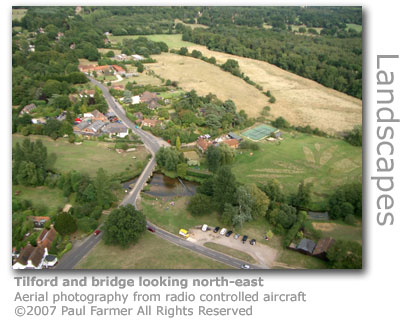
The village of Tilford of importance for a number of reasons. The first, and of direct relevance here, is that the village nestles on the banks of the two River Weys as they meet for the first time to join as a single river headed towards the Thames. The confluence of the North and South Wey branches is just near the delightful village pub, the Barley Mow (GR: SU873435), which sits opposite a perfect English country village green on which cricket matches are regularly played in the summer months. Older names for the village included appropriately enough Tilford Green, and Tylford Bridge recognising this as an important ancient crossing point.
A village shop, church and infant and junior schools serve the community of around 700 people. The renowned Tilford Players regularly take to the boards at the Tilford Institute, which was designed by the acclaimed architect Edward Lutyens opposite the village green, with the Institute building serving as the village hall. Other village organisations contribute to this vibrant village community and include the Horticultural Society, the Cricket Club and the Tilford Bach Society which specialises in performances of Baroque music using authentic instruments and orchestration. The Ahmadiyya Muslim Centre Islamabad was established in the Old Sheephatch School (GR: SU876443) after it closed in 1977 and serves as an Islamic education centre. Until recent years in July members from all over the world would converge on Tilford for a three-day convention but as the visitor numbers continued to climb (eventually exceeding 20,000) an alternative venue had to be found. Following threats and a fire bombing (July 2005) extra round-the-clock security has had to be put into place at the building
A filmmaker, British Films, in 1948 produced a part-documentary part-fiction film with commentary exploring Sheephatch when it was operating as a Camp School. The public service film today provides an insight into teenage schoolchildren's activities in the the difficult post-war years.
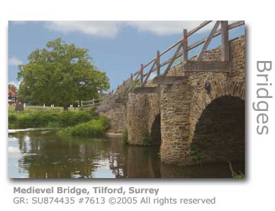
CLICK HERE FOR SHEEPHATCH FILM CLIP Two medieval bridges (GR: SU873436 and SU874435) cross the Wey here, part of a series of six early bridges (the others including Elstead, Eashing and Unstead), although the western one that had fallen into considerable disrepair has just been completely rebuilt (completed 2005) retaining its medieval character. The 13th-century structure, which is an English Heritage Scheduled Monument, was restored by Hampshire based Scott Wilson plc, a construction consultancy specialising in transport solutions, and has been protected from the day-to-day punishment of traffic by the construction of a brand new modern bridge to replace a crossing erected alongside the medieval bridge by the 55th Division of the Royal Engineers in 1941. The army bridge was built to withstand the movement of wartime tanks from a Canadian regiment based in the area. The Prime Minister's Better Public Building Award (1) has presented (September 2007) Surrey County Council with a plaque to mark the inclusion of Tilford Bridges in the award shortlist of 18 projects. The restoration work has also won the small civil engineering project award at the British Construction Awards (October 2007) beating 14 other national hopefuls. The semi-circular arches of the eastern bridge crossing to Tilford village itself suggest that the bridge was originally built by the Normans, however the cost of maintenance of bridges in the days before local authorities was shared by the landowners on each bank which meant that no particular fashion was followed in maintaining bridges to keep the costs down, and original features were often lost. (1) The Better Public Building Award was launched by Prime Minister Tony Blair to encourage 'good design' in publicly funded construction projects. The river downstream of the eastern bridge's weir is popular with visitors in the summer months as it is shallow, right by the green and within staggering distance of the pub.
Tilford was fortunate in that the both bridges were the responsibility of Waverley Abbey which ensured a consistency was retained. Historic annals recorded some disastrous floods occurring along the Wey in 1233 which had caused severe damage to local bridges. It is likely that many of the bridges between Farnham and Godalming were rebuilt around this time following the earlier semi-circular arches with semi-circular cut-waters downstream, rare in that this was not adopted anywhere else along the Wey. A seventh arch was discovered buried during re-strengthening of this eastern bridge in 1997.
The ancient oak tree (GR: SU873435), which is thought to date back to well before 17th century (although popular legend would claim an age of 1,000 years), is unhappily also nearing the end of its life and rests wearily near to the pub cordoned off by a protective fence. The tree has inspired fierce loyalty many times over through its long life, the most notable of which was to trigger a mass disobedience against the all-powerful Bishop of Winchester who as Lord of the Manor owned the land on which the tree stood at the time. The Bishop had ordered his foresters to fell the tree, but their axes were prevented from penetrating the bark by hundreds of nails the villagers had hammered in to deflect their blows. Local legend also holds that Charles II once hid in it, that a Waverley monk hanged himself from it and that John Wesley, the founder of the Methodist Church, once preached beneath it. The green was eventually given to the community by the Manor of Farnham in 1835.
About half a mile upstream from the village on the north branch of the Wey is the site of an ancient mill. Close to Sheephatch Lane, Tilford Mill (GR: SU869443) was in business as far back as 1367 when it was a fulling mill for the woollen industry. Further reference to the site as Wanford Mill, then milling corn, was made in 1679. There was an active corn mill here until 1850 with the mill demolished in 1866. Part of the miller’s house survives today as Tilford Mill Cottage. The bridge carrying Sheephatch Lane is named after the mill and is another of the bridges built by the Waverley Abbey monks although centuries of repairs have significantly altered it.
Tilford has been home to a number of worthy names. These include J M Barrie (1860 – 1937) who wrote the stories Peter Pan and Dear Brutus at nearby Black Lake MORE HERE, and Philip Snowden (1864 – 1937) who lived just outside the village at Woodlarks and spent the last years of his life here. Snowden worked closely with Ramsey MacDonald for thirty years to build up the strength and reputation of the Labour Party. As Chancellor of the Exchequer his debating skills on the floor of the house were legendary, and were often conducted in great pain inflicted by his severe physical disabilities. William ‘Silver’ Beldham (1766 – 1861), a legendary cricketer at the time, lived in a cottage on the edge of the green. After his retirement he became landlord of the Barley Mow overlooking the cricket green, a fitting place to end one’s days. Silver’s ghost reputedly has taken up residence in the pub. Close to Tilford House (GR: SU871436) is an ice house near the river bank in which meat and fish was kept fresh with ice cut from nearby Stockbridge Pond and the river whenever it froze over. The local policeman used to use it as a temporary cell in which to sober up village drunks to save him having to walk them all the way into Farnham. There is also a well preserved lime kiln (GR: SU865441) close to the Tilford Road and Sheephatch Road junction. Lime (calcium carbonate) has many uses including for breaking up clay soil on fields, as a building mortar, lime wash waterproofing for buildings, and for preparing hides in leather-making. A typical early lime kiln would measure around 18 feet (5.5 m) in height and be lined with bricks with an access hole at the base. The heat of the burning fuel, which was controlled by opening and closing a vent in the chimney, breaks the limestone down into pure lime or ‘quicklime’ which is the end product. Mortar made from lime is remarkably durable and many ancient buildings still in existence today were built using this mortar. This was made by dousing quicklime with water to turn it into ‘slaked lime’ and to which would be added sand to make a thick paste, exactly as we make modern cement based mortar today. CROSS OVER TO THE NORTH BRANCH OF THE RIVER WEY CARRY ON TO THE RIVER UNITED FROM TILFORD TO GODALMING © Wey River 2005 - 2012 |