|
HOME |
The Devil's Punch Bowl Since the 1970s campaign groups have put pressure on government to put an end to the choking effect of thousands of motorists skirting the edge of one of the nation's most important beauty spots. Here we follow the last few years of the campaign and celebrate its successful conclusion. |
|
|
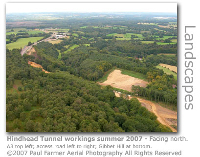
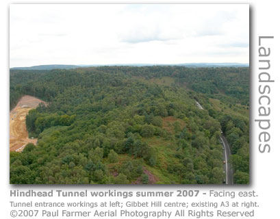
A Recent History The Devil's Punch Bowl (GR: SU895363) is a nationally important site of natural beauty and with the adjoining Hindhead Commons provides important habitats for wildlife. For decades the area, which includes a Site of Special Scientific Interest, has suffered from choking fumes and noise pollution emitted by 21,000 vehicles a day travelling along the A3 which provides the main road artery between London and Portsmouth. MORE ABOUT A local cyclist campaign group gave this brief account of the history of the stretch of road in question during a Cycle Campaigns Conference (2005) following the 2004 A3 Hindhead public inquiry.
Pressure at local and national level has been put on a string of incumbent governments since the 1970s to find a solution to the damaging pollution and congestion in order to return the area to the quiet and natural backwater it once was. A favoured solution is to excavate a tunnel that would run beneath the 894 ft (272 m) high Gibbet Hill (GR: SU901361) on the eastern flank of the ampitheatre and that would also relieve the small village of Hindhead. Various reviews had previously concluded that any surface road solutions would be more damaging to the sensitive local natural habitats than remaining with the existing road. Gibbet Hill is the second highest hill in Surrey. Approval Agreed Although in 1993 the Government had agreed that the preferred solution would be twin bored tunnels, funding for the 1.1 mile (1.8 km) tunnel project was not finally approved until early July 2006 with an estimate of £320m for the project. The completed new route will cover a total of 4 miles (6.5 km) of dual carriageway. After pressure from local MP Jeremy Hunt the government belatedly published the report into the enquiry. The report of 300 pages released by the Department of Transport (DoT) has raised new concerns over the scheme. It recommends an additional six-week consultation focusing on the finances of the project due to a large increase in costs having been identified. The DoT also recommends that the old A3 be closed off completely which will please conservationists but has strong local opposition.
There is also concern that if too many objections are brought to bear the scheme will be scrapped completely requiring campaigners to continue with their 30 year long battle.
The Secretaries of State for Transport, Communities and Local Government said that they are "minded to accept" the inspector's recomendation. However their final decision will be taken based on the findings of the new limited consultation exercise which will examine an increase of £50m in costs bringing the estimated cost to £370.9m. Other groups are concerned that the massive project will draw money away from other important road schemes, especially as the A3 tunnel has at last been given priority status.
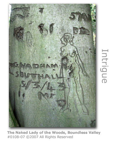
Source: Although the carving on the remotely located 400-year-old beech tree was already known to the Forestry Commission, National Trust and local historians this 'discovery' resulted in a brief flurry of interest in the national media as they tried to track down the mysterious G. Wadham in a bid to find out who the carving, dubbed by the newspaper red tops as The Naked Lady of the Woods, depicted. Locals believed the work was done by a British soldier on wartime exercise, or was perhaps that of a Canadian serviceman as there was a large Canadian army camp nearby. However a journalist from the Daily Mail eventually determined that there had been one Gerald Wadham who settled in the Hindhead area after the war when he ran a shop and a pub, and coincidentally was living in Southall in 1943. Sadly he died five years ago and his family were unaware of the carving, so the identity of the woman went with him to the grave, if indeed he was the creator. The Daily Mail's claim that the route of the tunnel road was diverted in order to save the tree was officially denied by our contact at the contractors. The tree and its mysterious woman is safe for future generations to ponder upon. Split over Plans to Close Old A3 Environmental groups have publicly welcomed the plans to close the A3 that skirts the edge of the Devil's Punch Bowl once the tunnel is built. The National Trust, who own the beauty spot, believe that the project will result in reuniting 'one of the most dramatic and inspirational landscapes in the Southeast' for nature conservation, recreation and tourism.
English Nature see the road closure as helping their work in protecting ever endangered heathland across the Wey Valley.
The Countryside Agency welcome the plans as a chance to create new tourism in the area.
Source: Other groups including those campaigning for a better deal for cyclists oppose the removal of the route of what will become the 'Old A3' as it will in effect eliminate an access route around the Punch Bowl (and avoiding the tunnel) up into Hindhead. New Consultation to Examine Escalating Costs Local residents and parish councils are beginning to get nervous over what they see as deliberate delaying tactics for the Tunnel approval with the imposition of the additional six-week consultation to assess the spiralling cost estimates of the scheme. The costs have risen by £50 million to £370.9 million since the close of the public enquiry, and many secretly feel that this increase is probably understated anyway. Thursley Parish Council councillors are fearful that this may provide an excuse for the government to cancel the project.
The other options on the table to ease congestion at Hindhead include providing new carriageways, which would cost at least the same as the tunnel but without the environmental benefits, and the building of a bypass (the Outer Western Route or OWR) at £347.4m is not much cheaper and will effectively just create environmental problems elsewhere, a view supported by environmental groups.
Source: Draft Timetable The fact that a draft timetable for the construction of the Devil's Punch Bowl tunnel has now been formally drawn up by the Highways Agency (1) suggests that the project has a good chance of at last becoming reality after a thirty year campaign. An announcement is expected by the Department of Transport in October providing ministerial support to the scheme.
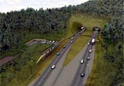
The MP and wildlife groups are concerned that the preparatory work at the entrance to the tunnel should be started before next spring to prevent any conflict with nesting birds, some species of which are protected. Once the scheme gets the green light, the process of drafting orders for the project will take the Highways Agency three to four weeks to complete. Planning laws then provide for a six week High Court challenge period on each order. This timetable would allow the Highways Agency to occupy the land needed for the project to be acquired through compulsary purchase (2) early in January 2007 to begin clearance work. Enabling Works would progress through the year in readiness for tunnelling to begin in 2008. The whole project would take about four years before the tunnel is ready to accept traffic. An overview of the project's plans and cut-away drawings of the planned tunnel can be viewed on the Highway Agency's website. (1) The Highways Agency is an Executive Agency of the Department for Transport. The agency has responsibility for operating, maintaining and improving the strategic road network in England for the Secretary of State for Transport. (2) The Planning & Compulsory Purchase Act 2004 gives the government, local council or utility company the legal right to buy or take rights over private property if it falls within a public or private construction project such as road building. The land would be purchased according to real market values assessed with the impact of the scheme factored out. Sources: Full Government Approval - Tunnel to Go Ahead The Government has finally announced (October 2006) that it is willing to fund the £371m cost of building the twin-bore tunnel to carry the nationally important A3 under Gibbet Hill at the Devil's Punch Bowl. The decision was made jointly by the Secretary of State for Transport, the Secretary of State for Communities and Local Government, with the Secretary of State for Environment, Food and Rural Affairs who has responsibility for the common land needed for the scheme. The National Trust, who own and manage Hindhead Commons and the Punch Bwl, reacted with relief to the news.
Initial environmental works are due to begin in January 2007 to prepare for the commencement of the main scheme works in April 2008. The tunnel is expected to open in 2011 in time for the London Olympics the following year. The Highways Agency has said that boreholes have already been sunk and work will start at the Thursley end and at Tyndall's Wood. Projects to address wildlife concerns especially over the welfare of dormice and nesting birds will start quickly to ensure that threatened species are moved to a safe habitat. Once the tunnel is open restoration of the landscape around the old A3 will be started. Over 400 hectares of open access heathland will be saved from the strangling effect of the heavy traffic that currently passes through it.
The tunnel plans include underpasses that will provide horse-riders, cyclists and pedestrians with crossing points under the new A3 approach roads. There are also plans to lay down 4 miles (7km) of cycle-friendly tracks. Highways contractors are moving on-site as scheduled (April 2007) to commence the construction of the three underpasses, two at the north end of the tunnel (Greensand Way and Hindhead Farm) and one on the south end (Canadian Memorial). The northern underpasses are scheduled for completion by December 2007 and the southern by July 2008. Clearance work to prepare the ground began in January with preparatory tree clearance in Tyndall's Wood and Boundless Copse. Sustainable development funding has now been approved (April 2007) which will provide for the wildlife conservation and landscape restoration work that will be required once construction ceases. The funding will also enable a bike guiding project and allow rural road signs to be erected. More than 400 hectares of open access heathland will become available once the existing A3 is closed down. The area will be opened up to walkers, cyclists, horse riders and people with disabilities.
Source: Alec McCalden, who volunteered his services on behalf of local cycle groups to ensure that cyclist's views and needs were aired throughout the long and tortuous tunnel campaign, was named (April 2007) volunteer of the year runner-up by the national organisation Cyclist's Touring Club (CTC).
Source:
The Tunnel - Some Facts The following description is published (May 2007) on the Highways Agency website.
Source: The excavations for the approach road and construction service roads have unearthed two lime kilns (1) which were common in the area during the 18th and 19th centuries. Both kilns are located on the Thursley side of the works and would have been fuelled with coppiced wood, most likely from the adjacent Boundless Copse. The lime, produced from limestone or chalk probably from the Petersfield area 15 miles (25km) away, would have been used locally for domestic and agricultural applications, and in particular as an alkali soil conditioner to counteract the acidic nature of the soil around the large areas of heathland.
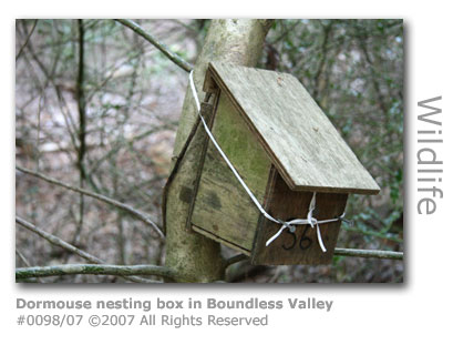
The site has disrupted natural habitats and of particular concern were dormice. The construction teams have adopted clearance methods which saw 160ft (50m) wide strips cleared representing typical foraging distance encouraging the animals to move into areas of similar habitat away from the construction. During the winter dormice hibernate in hollows at the base of trees so trees were felled leaving the stumps in place. Where full disturbance was unavoidable hand searches by licenced handlers for dormice were conducted and any animals found relocated to a safe location nearby. Seven temporary dormice bridges were also erected to ensure remaining animals could escape to safety. 50 dormice boxes have now been erected in the Boundless valley and another 50 in Tyndalls Wood. At the end of May (2007) nine boxes were found to be inhabited. No further tree felling is scheduled until September and October 2007 to ensure that young dormice will have had a chance to leave the nests.
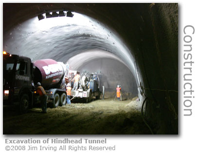
Four species of reptile have been found in Boundless Valley. The common lizard, adder and slow-worms found have all been relocated to National Trust land at Highcombe Edge. Grass snakes were taken to Hurthill Copse which has more suitable prey. Excavations of trenches for laying service pipes presented a particular problem in that adders were falling into the trenches overnight. The laying of planks to allow escape from the trenches proved only partially successful and each morning a snake handler had to rescue any remaining adders before work could resume. Source: Tunnel - the First Cut The north portals for the Hindhead Tunnel have started to be excavated as state-of-the-art machinery started the work of digging the 1.2 mile (1.9km) long tunnels. Transport Minister Ruth Kelly on 1st February 2008 was on hand to officially start the excavation which will see the contractors working around the clock in order to meet their completion deadlines. One of the excavators provided a ceremonial boring into the hillside. Advanced technology will provide satellite guidance and a profiling system that constantly monitors ground conditions to provide automatic machinery adjustments during excavation. The machinery operators are guided by computer screens providing real-time data as the team pioneer in the UK the use of primary lining and profiling systems. The tunnel lining process involves providing a concrete layer upon which a waterproof membrane followed by a fire-resistant lining are added. The engineers will be helped by the fact that most of the strata lying ahead is of sandstone which behaves like rock and so is easier to tunnel through whilst retaining the tunnel walls. Material extracted during boring will be recycled and used in embankments, screening bunds and landscaping. The latest timetable for construction is currently:
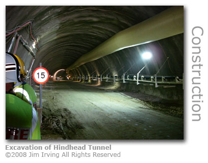
Five Hundred Yards and Still Digging By the 19th August 2008 1,732 feet (528m) had been dug into the side of Gibbet Hill on both the south and northbound tunnels. representing significant progress. To be precise this milestone was of the excavation of the 'heading' or top part of the tunnel from the North Portal for the two carriageways.
The excavation is undertaken in stages with the top half of the hole being bored excavated first, and then the 'bench' or bottom half of the tunnel cleared afterwards. The contractors are working on the two tunnels simultaneously and from both ends. At this stage as well as the progress detailed above the boring crews had dug 213 ft (65m) of heading from the southern end of the southbound bore and 289 ft (88m) from the northbound.
Work on the various underpasses that will handle interesecting roads to the tunnel approaches have also been progressed to various stages. The underpasses by the Canadian Memorial and Greensand Way were nearing completion and those at Hammer Lane and High Pitfold were under construction, as was the Hazel Grove overbridge. First Underpasses Opened The Canadian Memorial Underpass, which provides pedestrian access beneath the existing A3 joining for the first time the two halves of Bramshott Common, was officially opened in September 2008. The ceremony was attended by war veterans and ramblers, the latter who have welcomed the route which now provides unfettered access beneath the A3 dual carriageway. The Greensand Way Underpass near Thursley was opened in October 2008 providing a safe crossing for one of England's most popular long-distance footpaths. A storm has broken out over emergency cover for the Hindhead Tunnel by fire crews. Given the location of the tunnel the two closest fire stations are Godalming and Haslemere neither of which have full permanent fire crews and from which 20-minute attendance times are projected. However the Fire Brigades Union (FBU) has criticised a supposed lack of definite plans and have recommended that a new fire station be sited at Milford to provide faster response times.
The Surrey Fire and Rescue Service however has said that that there were 'in principle' plans already agreed to respond to a range of incidents.
The Highway Agency, which is managing the project, appear to be confident that the rescue service has everything in hand.
Source: Return to Heathland After almost two centuries of being divided by a main route linking London with Portsmouth the Highways Agency was tasked with reuniting the heath and woodland around Hindhead. Around 1,600 acres (647 hectares) of countryside will benefit from the landscaping works, which commenced in August 2011, transforming the route of the old A3. Stretches of the tarmac road have been removed with other sections covered with sandstone excavated from the tunnel during the build. The unmetalled byway further up the hill, and which follows the route of the original ancient highway along which stagecoaches used to ply their trade, will remain. The road will be resurfaced to provide a safe path for cyclists, walkers and horse riders. Preparations for Opening the Tunnel The public walk-through of the tunnel in May 2011 raised much-needed funds for local communities. Over 7,000 people paid for the privilege of walking through the completed tunnel before it opened in July. The walk, organised by the Hindhead Together partnership, was led by a group of MPs and mayors. Haslemere Town Band played enthusiastically throughout the day. One of their members, 16-year-old Eric Foster, had composed a piece especially for the event: The Devil's Punch Bowl March. Foster's parents house is sited directly above the path of the tunnel. SEE VIDEO OF WALK-THROUGH : Links to YouTube video uploaded by Surrey and Berks Media The Community Foundation for Surrey processed applications. Thursley Village Hall used their share of the money raised to make the entrance to the community facility easier to locate to boost awareness. An oak ladder sign was crafted by Norbury Wood Products, part of Surrey Wildlife. Encouraged by an official charity walk through the completed Hindhead tunnel before it opened that had raised much-needed funds for the Prostrate Project, the charity is hoping that a video documentary about the tunnel's construction will raise further funds. The local community walk raised almost £2,000 which was split equally between the Prostate Project and Haslemere Museum. The twenty minute documentary Under the Devil's Punch Bowl was filmed between 2007 and 2011, and was shown at the visitor centre exhibition, is available on DVD from the Haslemere Museum for £6.
The Prostate Project's Pint-A-Week appeal was set up to finance a new NHS urological centre at the Royal Surrey Hospital in Guildford. The Tunnel Opens The Hindhead Tunnel opened for traffic on Wednesday 20th July 2011 after four years of construction work and 30 years of campaigning and hand wringing to seek an end to the effects of choking traffic at the Hindhead crossroads bottleneck. The 1.25 mile (2 km) tunnel cost £371m to complete. The opening ceremony was conducted by Philip Hammond, transport secretary with Jeremy Hunt, South West Surrey MP. Neither Baroness Virginia Bottomley nor her husband Peter Bottomley a former transport minister, and both of whom who had campaigned for the tunnel for over 20 years, were able to attend the event.
VIEW VIDEO OF OPENING : Links to YouTube video uploaded by Surrey and Berks Media A police escort led the first vehicles through the tunnel, which included a procession of vintage cars and motorcycles. A Liphook resident maintained a blog throughout the tunnel build. Dave Wareham, who provided a fascinating personal account of progess since work started in January 2007, had to miss the ceremony due to a family holiday. He was said to have been 'gutted'. MORE HERE What Now for Hindhead Businesses? Local businesses on the once traffic-choked crossroads at Hindhead are facing an uncertain future since the tunnel has opened. Traders in the village are taking a day-by-day approach to see what is going to happen. Perhaps predictably one of the three remaining petrol stations along the now old A3 has already closed. The following survey of some Hindhead businesses was published by The Petersfield Post (7th August 2011):
Businesses further afield are concerned about a reduction in business due to the effects of new road signage. Retailers in Midhurst, which used to benefit from signposting to the town from the Hindhead crossroads have in their view been 'wiped from the map' as sliproads south of the tunnel make no reference to the town.
TAKE A PHOTOTOUR OF THE TUNNEL CONSTRUCTION SITE |
||
|
© Wey River 2005 - 2012 : All rights reserved |